- Home
- Works & Tech
- What Is 3DGS (Gaussian Splatting)? Differences from Point Clouds and Uses in Construction
Tech Articles3DCG
What Is 3DGS (Gaussian Splatting)? Differences from Point Clouds and Uses in Construction
How WAN, the developer of a 3DGS viewer, sees the division of roles with point clouds
3D Gaussian Splatting (3DGS) is a technology that uses photos or video to reproduce real places as 3D spaces that look close to photographs.
In construction and civil engineering, point clouds have long been used to record sites as 3D data. So when people first learn about 3DGS, many wonder how it differs from point clouds and whether it can be used for surveying.
3DGS and point clouds differ not only in appearance but also in the nature of their data and the uses they are suited to.
This article explains the basics of how 3DGS works, how it differs from point clouds, and how to put it to practical use in construction.
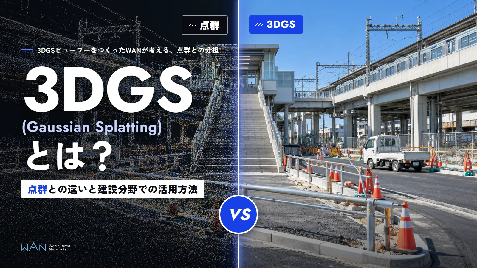
01What is 3DGS?How does 3DGS create a 3D space from photos?
3DGS is a technology that reproduces a photographed space in three dimensions from multiple photos or videos.
The 2023 paper "3D Gaussian Splatting for Real-Time Radiance Field Rendering" proposed a method that represents a space with a large number of 3D Gaussians. Each Gaussian holds not only a position but also information such as size, orientation, color, and opacity. By combining them, 3DGS can render views from positions that do not appear in any of the original photos.
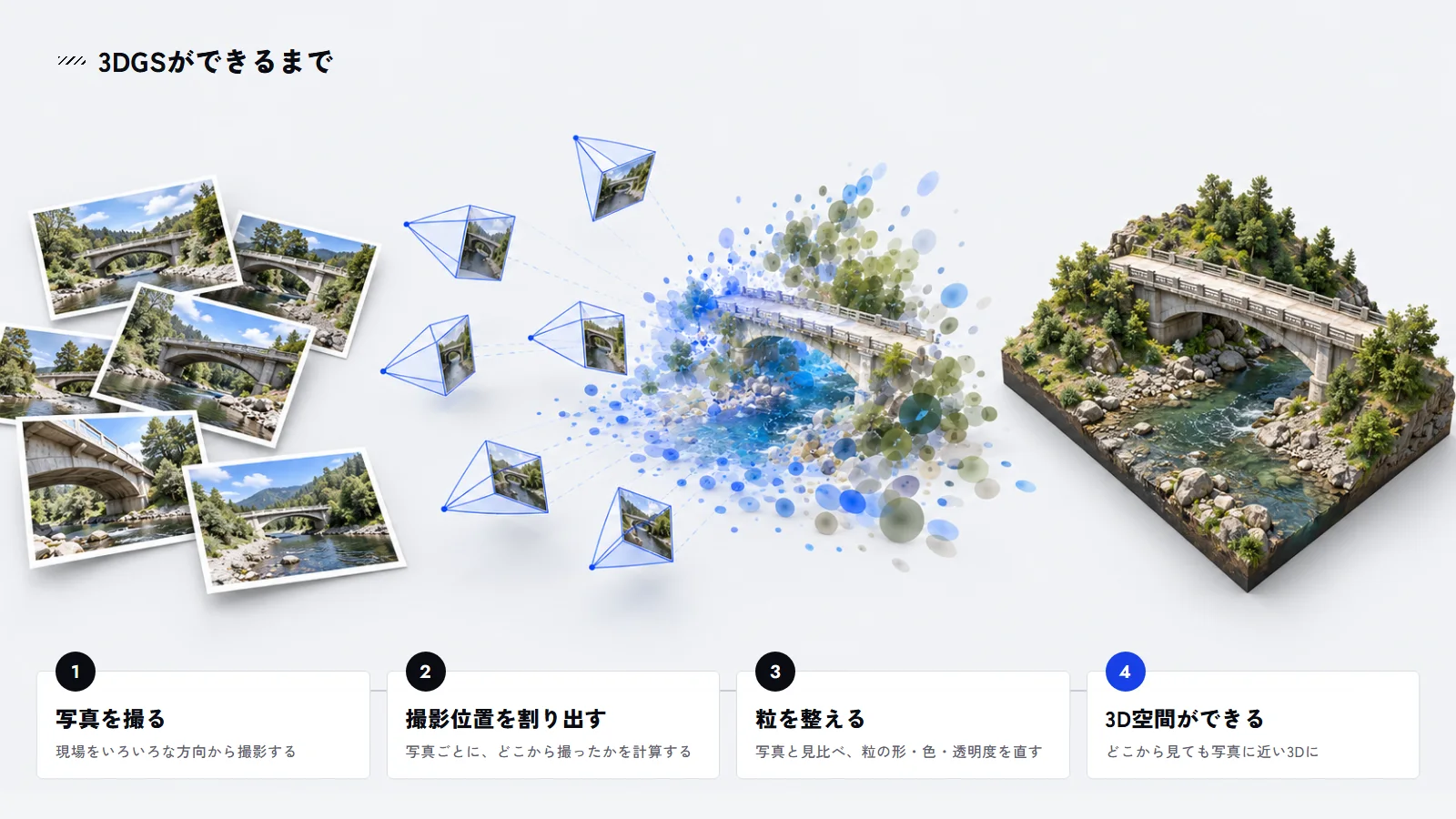
An ordinary photo shows a site from the position and direction in which it was taken. With 3DGS, you move the viewpoint within the generated 3D space and check the surroundings of a building or the road ahead from different angles.
Even before 3DGS appeared, technologies such as NeRF were being researched for generating images from new viewpoints based on photos. 3DGS was proposed as a method that achieves both high-quality rendering and near-real-time display speeds.
Editor's note
3DGS is not a technology that simply turns photos into 3D as they are.
It estimates the camera positions and how the space appears from multiple images, and reconstructs them as a 3D space. As a result, the number of photos, the shooting angles, and how the subject appears all affect the result.
02Differences between 3DGS and point cloudsCan 3DGS be used for surveying in place of point clouds?
Point clouds are what 3DGS is most often compared with.
A point cloud is data that represents an object or space as a large number of points with 3D coordinates. Point clouds can be acquired with laser scanners, and they can also be generated from photos.
Point clouds acquired with surveying-grade laser scanners in particular allow the shape and position of existing conditions to be handled as numerical values, so they are used for surveying, as-built management, drawing production, comparison with BIM/CIM models, and more.
3DGS differs from such point clouds both in how it represents data and in its main purposes.
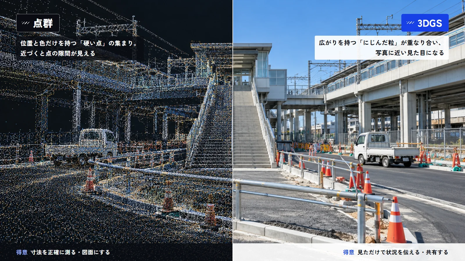
| Item | Point cloud | 3DGS |
|---|---|---|
| Main representation | Points with 3D coordinates | 3D Gaussians with size, orientation, color, opacity, and other properties |
| Appearance | Displayed as a collection of points | Readily reproduces a near-photographic appearance |
| Measuring shape and position | High-precision measurement is possible, depending on the equipment and processing methods used | Accuracy varies with the creation method and the coordinate and scale settings |
| Main uses | Surveying, as-built management, design, analysis | Checking existing conditions, recording, explaining, viewing 3D spaces |
| Viewing the data | Requires point cloud software or similar tools | Depending on the viewer, can be viewed in a web browser or similar |
Note that the distinction is not as simple as "point clouds are always highly accurate" and "3DGS cannot be used for measurement."
The accuracy of a point cloud varies with the equipment and acquisition method used. With 3DGS, too, if the real-world scale and coordinates are set appropriately, it can be used to check distances and positional relationships in 3D space.
However, 3DGS itself does not guarantee survey-grade accuracy. In work that relies on precise dimensions or positions as evidence, you need to check how the source data was acquired and how accurate it is before using it.
Editor's note
Point clouds and 3DGS are not something you choose between based on which is better.
The right data depends on whether you will treat it as survey values or use it to check site conditions. Deciding the purpose of the work first makes it easier to sort out which to use when.
03Uses suited to 3DGSWhere can 3DGS be used on construction sites?
3DGS is suited to situations where you want to check not only the shape of a site but also its surroundings and how it looks.
Recording sites
If you save a site as 3DGS before or during construction, you can later check its condition while changing the viewpoint.
With ordinary photos, you cannot later look in directions that were not photographed. With 3DGS, you can review the surroundings from other angles, as long as they are within the area reconstructed from the captured data.
Keeping data from each stage, such as before, during, and after construction, also provides a record of how the site has changed.
Remote site checks
3DGS is also suited to helping staff who are not on site understand the surrounding conditions.
When you explain a specific location using photos alone, the positional relationship between an object and its surroundings can be hard to grasp, depending on where and in which direction the photos were taken. In a 3D space, viewers move the viewpoint themselves and check the situation, including the area around the object.
When stakeholders in different roles, such as clients, designers, and contractors, discuss the same site, it becomes easier to make sure everyone is looking at the same place.
Comparison with design models
Another use is to overlay design models such as BIM/CIM on the existing conditions reproduced with 3DGS.
Placing the existing conditions and a design model in the same 3D space makes it easier to check where equipment would go, how it relates to its surroundings, and roughly how the site will look when complete.
This approach is useful for studying layouts before construction and for confirming differences between existing conditions and plans among stakeholders.
Editor's note
A defining feature of 3DGS is that you can later review a captured site from different viewpoints.
However, areas that were not photographed, or parts where not enough information was captured, will not be reproduced. It is important to shoot with the areas you will want to check later in mind.
04Points to note when using 3DGS in your workWhat should you check to keep using 3DGS in day-to-day work?
Being able to create 3DGS does not necessarily mean it will be easy to use in your work as is.
For ongoing use in construction, you need to plan operations that cover accuracy, data size, and how the data is shared.
Check the measurement accuracy
Being able to display distances in a 3D space is not the same as being able to treat those numbers as survey values.
The accuracy you get depends on the equipment used to acquire the data and how the scale and coordinates were set.
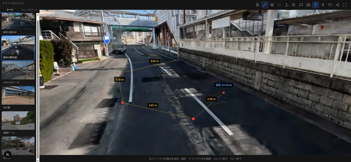
In work where the numbers themselves serve as evidence, such as surveying and as-built inspections, you need to confirm in advance that the required accuracy is met.
Consider the data size
For large sites or high-resolution data, 3DGS data can become large.
Even if the data displays without problems on the computer used to create it, it may take time to load on another staff member's computer or on a smartphone.
When sharing with people outside your company, you need to consider how much data can be handled, taking into account the viewing devices and network conditions.
Decide how to share
When using 3DGS in your work, it also matters who will view the data you create and how.
If dedicated software must be installed, the effort of preparation and explanation grows as the number of people you share with increases.
When people who do not normally use 3D software, such as clients and partner companies, will view the data, one option is to use a viewer that opens in a web browser.
Editor's note
When trying out 3DGS, attention tends to focus on whether you can create clean data.
In actual work, you also need to decide who will view it afterward, what it will be compared with, and where the findings will be recorded.
For ongoing use, 3DGS is easier to build into your work if you plan operations that include viewing and sharing, not just the creation method.
05How to view 3DGS in a web browserHow do you share 3DGS with people who do not have dedicated software?
Machica, developed by World Area Networks Co., Ltd. (WAN), is a 3DGS viewer for viewing 3DGS in a web browser and using it for site checks and information sharing.
In addition to displaying 3DGS, Machica can overlay 3D models such as BIM/CIM on the 3D space of the existing conditions.
It also supports measuring distances and areas, adding comments, attaching documents, and viewing the original photos. You can also share the location and viewpoint you are looking at via a URL.
For example, by displaying the existing conditions as 3DGS and placing a BIM/CIM model on top, you can compare the current state and the plan on the same screen.
When there is something to check at a specific location, you can leave comments and documents at that position, so discussions are managed together with the places they refer to.
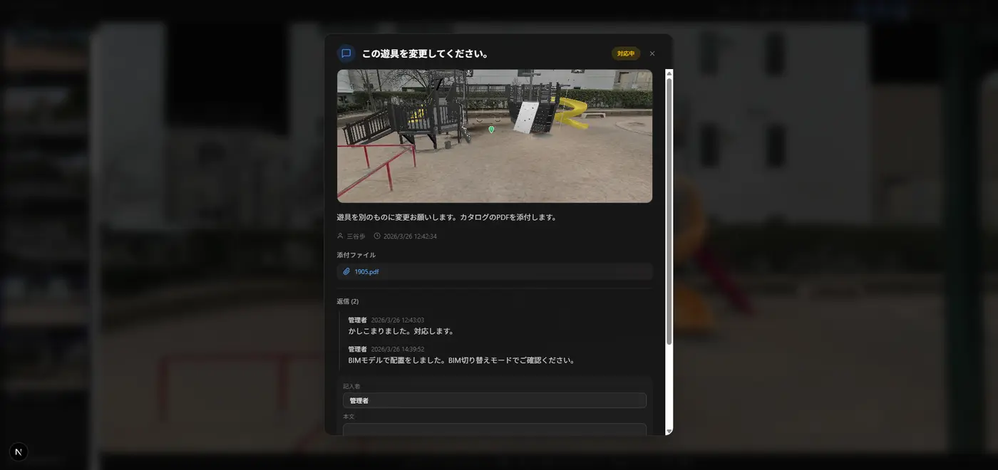
Machica offers the following features:
- Display of 3DGS
- Overlay of 3D models such as BIM/CIM
- Measurement of distances and areas
- Comments
- Attachment of documents such as PDFs
- Viewing of the original photos
- Sharing of viewpoints and locations via URL
A viewer like this becomes necessary when you use 3DGS not only to create data but also for subsequent checks and sharing with stakeholders.
06Choose between 3DGS and point clouds according to the purposeHow should point clouds, 3DGS, original photos, and BIM/CIM be combined?
3DGS and point clouds differ in how they are acquired and in the nature of their data.
For work where positional and dimensional accuracy matters, such as surveying and as-built management, point clouds acquired by a method that meets the required accuracy are the right choice.
3DGS is suited to turning a site into 3D with a near-photographic appearance and checking conditions while changing the viewpoint. Its main uses include site records, remote checks, and studies with design models overlaid.
In actual work, you do not need to standardize on just one of point clouds, 3DGS, original photos, or BIM/CIM. Use each according to what you want to check and the accuracy you need.
Within this mix, Machica is a viewer for using 3DGS for site checks and sharing. Because BIM/CIM models, comments, and documents can be handled in the same 3D space, it brings together the operations that follow the creation of 3DGS.
If you want to use 3DGS on site but are unsure what data to prepare or how to overlay it with BIM/CIM, you can explore how to use it based on your actual data.
Editor's note
When introducing 3DGS for the first time, you do not need to replace all of your existing work.
One approach is to start with uses that make the most of how 3DGS looks, such as site records and internal checks. Then, expanding the areas where you combine it with point clouds and BIM/CIM as needed makes it easier to judge which approach fits your work.
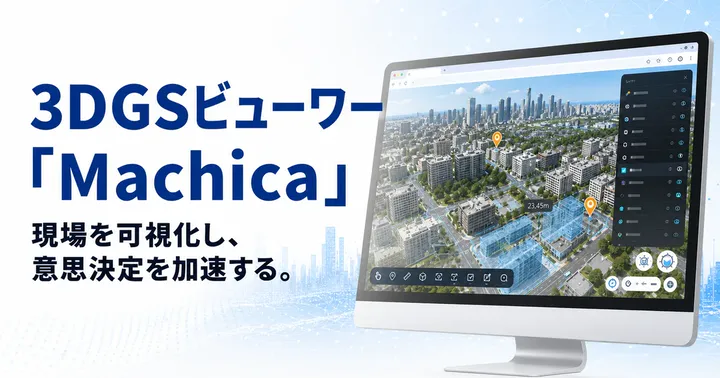
Product featured in this article
3DGS Viewer Machica
A service for viewing, measuring, and sharing 3D site data in a web browser. It supports BIM overlay, comments, comparison over time, and more. The beta version is currently available free of charge.
Sources and references
Bernhard Kerbl et al., "3D Gaussian Splatting for Real-Time Radiance Field Rendering," ACM Transactions on Graphics (SIGGRAPH 2023)
Gaussian splatting - Wikipedia
Machica user manual (beta) and feature overview materials